Nepal: update on landslide hazard following 12 May 2015 earthquake
British Geological Survey and Durham University
11:20 BST Tuesday 12 May 2015
Key messages (all observations based on available cloud free satellite imagery)
- The large earthquakes on 12 May occurred directly beneath the area that suffered the largest impacts from landsliding in the 25 April Gorkha earthquake. We expect that many additional landslides have been triggered in these areas.
- As in the 25 April earthquake, we expect that the landslides will comprise widespread rockfalls and debris avalanches that have a significant local impact and loss of life.
- The earthquakes on 12 May occurred very close to the pre-existing Sun Koshi landslide dam, which formed in 2014. This dam did not fail in the 25 April earthquake, but cracks around the margins of the landslide were visible in satellite imagery after the 25 April earthquake. It is possible that the 12 May earthquakes have either (1) weakened the dam, making it more prone to failure; or (2) weakened the slopes above the dam, making additional landslides possible. It is therefore extremely important that the dam be checked in the field for stability, the area above the dam checked for stability, and the water level monitored over the next 7-10 days.
- The additional shaking in Sindhupalchowk, Dolakha, and Ramechhap districts on 12 May will cause additional damage to already-weakened slopes. As before, many more damaging landslides are very likely to occur in the 2015 monsoon, which begins in c. 6 weeks.
Status
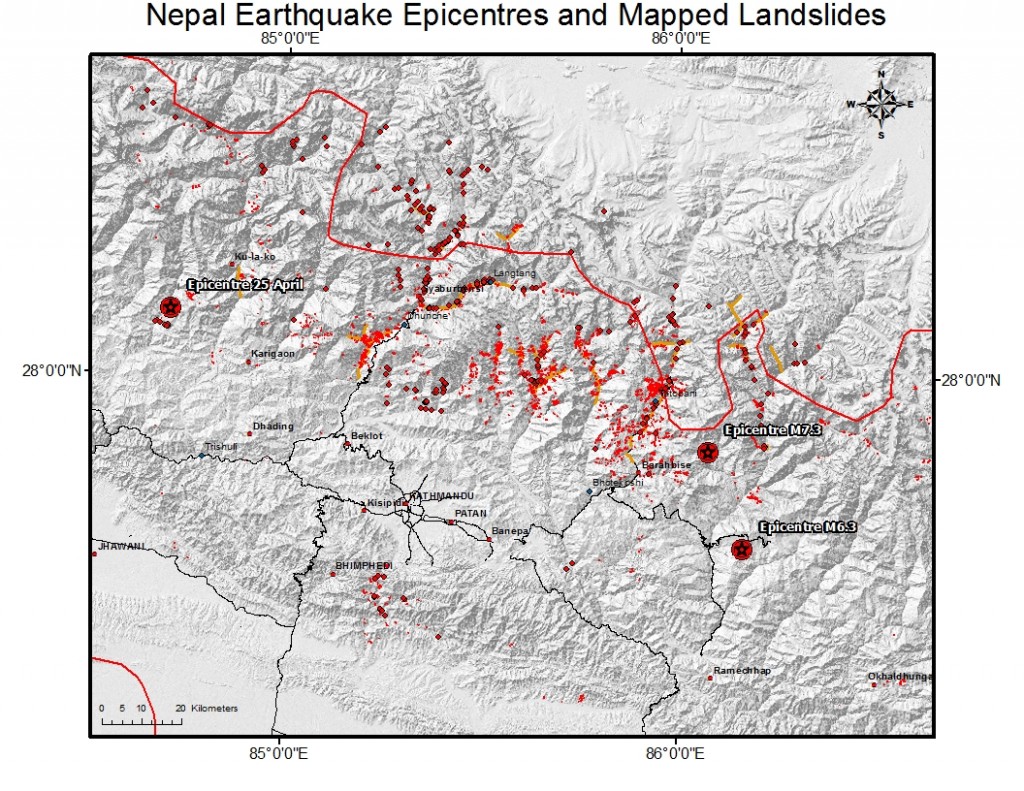
Until satellite imagery become available, we are using social media to monitor reporting of landsliding in the wake of this morning’s large aftershocks (M 7.3, M 5.6, and M 6.3) to the 25 April Gorkha earthquake. The 12 May aftershocks occurred at the eastern edge of the ‘patch’ that slipped on 25 April, directly beneath the area that was most affected by landslides triggered in the 25 April earthquake. The epicentre of the largest earthquake today (M 7.3) earthquake is located at Bigu (27.84°N 86.08°E), some 18 km SE of Kodari.
Figure 1. Location of epicentres and landslide distribution (until 11 May 2015).
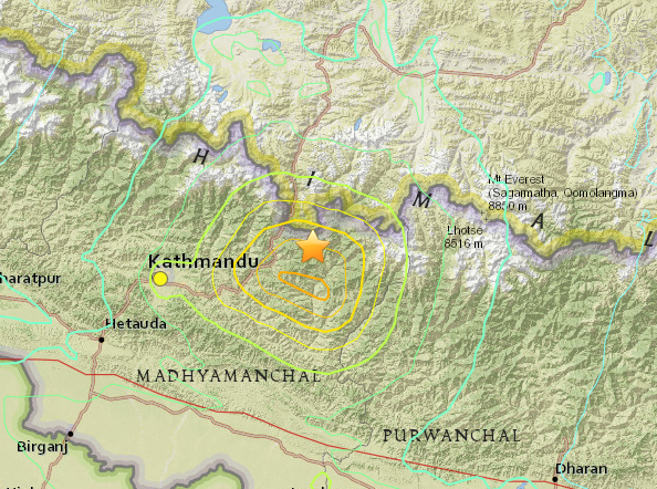
The region affected by elevated Peak Ground Acceleration (PGA) is much smaller than that of the Gorkha earthquake, with a focus on mid-elevation slopes (between 2000 and 4000 m altitude) in Sindupalchowk, Dolakha and Ramechhap districts (Figure 2).
Figure 2. Peak ground acceleration (PGA) map (USGS) from the M 7.3 earthquake on 12 May (source: http://earthquake.usgs.gov/earthquakes/eventpage/us20002ejl#general_map), illustrating where landsliding may be expected
The area of Sindhupalchowk, Dolakha, and Ramechhap districts suffered from widespread rockfalls and debris avalanches. These landlslides were extremely common across parts of the landscape, and ran out long distances from their sources to the valley floors. They had devastating impacts on villages and road networks throughout the area.
Because rock slopes were weakened in the Gorkha earthquake, we expect that the large earthquakes on 12 May will trigger many additional landslides – potentially as many again as were triggered on 25 April. These landslides are likely to be similar in type and size to those in the Gorkha earthquake, and the areas that were most affected by the Gorkha earthquake are again likely to have the largest landslide impacts today.
Additional landslides in this area have already been reported on social media. Until satellite images are available, it must be assumed that the Arniko Highway and other transport corridors (e.g., roads in the Tama Koshi valley, and roads into Bhimeshwor) will be blocked by additional landsliding this morning.
Possible effects on Sun Koshi landslide dam
The large Sun Koshi landslide dam, which formed in 2014, did not appear to be affected by the 25 April earthquake; there were no obvious changes to the dam itself, or to the water level behind the dam. We have recently acquired high-resolution imagery of the dam, taken between 25 April and 12 May, that appears to show some areas of cracking on the hillsides above the dam. This may indicate damage to the rock around the margins of the Sun Koshi landslide, which would increase the risk of further landslides onto the dam. It has not yet be possible to obtain field confirmation of this, however.
The 12 May earthquakes have raised the hazard at the Sun Koshi landslide dam for two reasons:
- They may have weakened the dam, which currently impounds a 1.2 km long lake. While the Sun Kosi River continues to flow through a channel over the dam, failure of the dam would release a large volume of water into the Sun Kosi and threaten the downstream villages of Khadichaur, Kothe, Balephi, Bhainse, and Sukute.
- They may have further weakened the hillsides above the dam, leading to further landsliding onto the dam and blocking the Arniko Highway.
It is extremely important that the dam and surrounding hillsides are checked for damage as soon as possible, and the Arniko Highway closed to through traffic if additional signs of instability are found. It is also imperative that that the water level in the lake is monitored over the next 7-10 days to check for leakage caused by shaking on 12 May and to watch for signs of catastrophic failure.
Alex Densmore, Tom Dijkstra, Colm Jordan, Vanessa Banks, Nick Rosser, John Rees, Gareth Jenkins and Jack Williams


