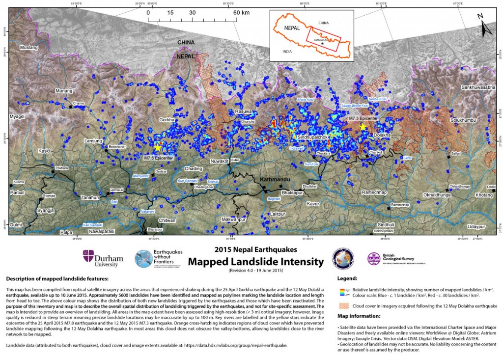
UPDATED (30 June) landslide inventory following 25 April and 12 May Nepal earthquakes
Please note: this is an updated landslide density map that includes, for the first time, landslides triggered by both the 25 April 2015 Gorkha earthquake and the 12 May 2015 Dolakha earthquake. It should be read in conjunction with previous posts on the effects of the 25 April Gorkha earthquake.
Key messages (all observations based on available cloud-free satellite imagery):
- Approximately 5,600 landslides have been identified to date, including new landslides triggered by the 25 April 2015 Gorkha earthquake and the 12 May 2015 Dolakha earthquakes, as well as reactivations of landslides that were present before the earthquake sequence began.
- Major or disruptive landsliding is limited to a zone that runs east-west, approximately parallel to the transition between the Lesser and High Himalaya. This zone includes parts of the districts of Gorkha, Dhading, Nuwakot, Rasuwa, Sindhupalchok, Dolakha, Ramechhap, and Khavre.
- Landslides triggered by the 12 May Dolakha earthquake are included in this data set for the first time. The area of landslides triggered by the Dolakha earthquake overlaps with the eastern end of the area affected by landslides in the Gorkha earthquake. In general, locations that suffered from high landslide intensities after the Dolakha earthquake also suffered from widespread landsliding in the Gorkha earthquake. These areas have suffered damaging levels of shaking in two successive large (Mw 7+) earthquakes, and must be viewed as having a very high risk of failure during the 2015 monsoon season.
- There have been numerous reports of cracked ground in the affected areas. There is no single interpretation of cracks in slopes generated during earthquakes and how these cracks are likely to develop through the monsoon. We recommend establishing simple monitoring (distance measurements between stakes positioned across cracks), to establish if cracks are widening or if movement of the slope has ceased. Areas that exhibit continued or accelerating movement should be treated with extreme caution.
Background and methodology
The purpose of this inventory and map is to describe the overall spatial distribution of landsliding triggered by the Gorkha earthquake sequence in April-May 2015, not for site-specific assessment. The image quality is low in steep terrain, meaning that precise landslide locations may be inaccurate by up to 100 m. The landslides have been identified and mapped using optical satellite imagery across the area that experienced shaking during the entire earthquake sequence, up to and including 19 June 2015, in addition to some reports from the ground where available. All landslides have been mapped as lines that start at the landslide head or upslope margin, and trace the landslide path to its toe. The colour on the map shows the number of mapped landslides per km2, ranging from 1 to a maximum of 29, to illustrate regional landslide intensity. Key rivers, valleys and roads are labelled, and the yellow stars indicate the epicentres of the Gorkha (Mw 7.8) and Dolakha (Mw 7.3) earthquakes.
All landslide data can be freely downloaded from ftp://topdog.dur.ac.uk/njr/nepal_eq/UPDATE_20150622/. Both high-resolution and low-resolution maps (in colour and B&W) available as PDF files. We have also posted the following shapefiles for use in ArcGIS:
(1) ‘Possible_Monsoon2014’ shows landslides which are considered likely to have been caused by either the Gorkha or Dolakha earthquakes, but where pre-EQ imagery is only available prior to the 2014 monsoon
(2) ‘Nepal_EQ_Landslides’ shows all mapped landslides which occurred as a result of the 2015 Nepal earthquake sequence.
(3) ‘150618_ImagePolygons’ shows the image extents used in mapping landslides following the 12 May Dolakha earthquake
(4) ‘150618_DolakhaCloud’ shows areas which remain obscured by cloud and unmapped since before 12 May, but were mapped between 27 April and 12 May
(5) ‘150618_TotalCloud’ shows areas which remain obscured by cloud and unmapped since before 27 April 2015
Details of each file are also available in the shapefile metadata.
.
Satellite data have been provided via the International Charter Space and Major Disasters and freely available online viewers: WorldView @ Digital Globe; USGS LandSat8; Bhuvan RS2; Astrium Imagery; Google Crisis. Vector data: OSM. Digital Elevation Model: ASTER.
Regional update:
Siwalik and Lesser Himalayan regions
- We have high confidence that there are few very large landslides, beyond those widely reported at higher altitudes (see below). Whilst locally destructive, most landslides are relatively small; many are re-activations.
- Analysis of villages/infrastructure known to have been damaged by landslides shows that the latter are almost all small and extremely difficult to identify using the available imagery.
High Himalayan region
- A zone of relatively intense landsliding and disruption can be mapped in every valley for which cloud-free imagery is available, northwest, north and northeast of Kathmandu, running from Gorkha to Dolakha districts. This zone contains numerous rockfalls and debris avalanches, with many events following pre-existing pathways or channels and having long runout distances (in most cases, all the way to the valley floor). These events are individually localised but together are extremely widespread, and have had catastrophic impacts on roads and villages. It is these small, but widespread, landslides that are likely to have caused the largest loss of life due to landsliding.
- Cloud-free images are not yet available for all valleys within this zone; until they are, we must expect that similar levels of disruption are present in ALL valleys within the zone, not just those indicated on the map.
- We, and various other groups, have identified several large valley-blocking landslides (landslide dams) on the basis of satellite imagery (see: ICIMOD). We stress that further valley-blocking landslides may still be found as additional imagery on currently cloud covered areas becomes available; other areas in the High Himalayas should be assumed to be at risk until the existence of landslide dams can be confirmed or ruled out.
- There remains a significant continued risk of new or reactivated landslides blocking river valleys, such as that seen in the Kali Gandaki on 24 May. Such landslides may occur without an apparent trigger.
- Where visible, high-elevation areas (> 3,500 m) show evidence of rockslides, along with extensive avalanching (the latter especially above 4,500 m). Most of these areas are far from permanent settlements or infrastructure, and pose no direct threat to the population.
Entire earthquake affected region
- The zone of intense landsliding approximately maps onto the areas with the highest seasonal monsoon rainfall, and those areas with the highest annual fatalities due to rainfall-triggered landslides (see: Dave Petley’s landslide blog). We must therefore expect that the risk due to continued landsliding in this area will escalate significantly during the 2015 monsoon. This continued landslide occurrence will threaten already-affected areas with continued failure, and will wash landslide sediment downstream onto valley floors and floodplains.
Recommendations
- Road access to, and through, the zone of intense landsliding is going to be very challenging at least through the 2015 monsoon season. This is both on major road corridors but also on seasonally accessible roads, which are likely to be in a heightened state of damage. It would be sensible to undertake a continuous survey of the major transportation corridors to identify where new problems are most likely to arise, problems are developing, and to prepare for the possibility of BOTH immediate action to clear rockfall debris AND continued clearance and maintenance of major roads after future landsliding. Note that all major roads to China in the affected area appear to have been heavily impacted.
- Collation of observations of the distribution, character and impact of landslides from people in the field is required to refine landslide hazard and risk assessments and validate the findings of the satellite-based survey we have undertaken. We have already instigated a social-media call to initiate this, but additional measures may be required, and a method of collation agreed. We note that field teams from Tribhuvan University and ICIMOD, and USGS are collecting data at present.
- There have been numerous reports of cracked ground in the affected areas. There is no single interpretation of cracks in slopes generated during earthquakes and how these cracks are likely to develop through the monsoon. We recommend establishing simple monitoring (distance measurements between stakes positioned across cracks), to establish if cracks are widening or if movement of the slope has ceased. Areas that exhibit continued or accelerating movement should be treated with extreme caution.
- Users of post-event map products, including our own, should be aware that several factors, unrelated to the actual distribution of landslides, may have influenced their apparent distribution: i) large areas of Nepal remain unmapped, largely because of cloud-cover and image availability, so these areas must be assumed to have been affected; ii) some maps are predictions based on pre-earthquake landslide susceptibility evaluations rather than observations post-event; and iii) different methods have been utilised by respective agencies to map landslides (for instance, some may not have taken full account of the occurrence of pre-existing landslides in their assessment of landsliding associated with the event).


I would like to download landslide inventory data from the link given in this website. But the link is not working. (ftp://topdog.dur.ac.uk/njr/nepal_eq/UPDATE_20150622/)
I am currently performing a reserach on analysis of cascading impacts of multiple hazards at Karlsruhe Institute of Technology as Alexander von Humboldt Fellow. I would like to use landslide inventory data for hazard and risk mapping for the power network in Nepal. I am open to any colleboration on this issue.
Thanks in advance
Prof. Dr. H. Sebnem Duzgun
The link for download of data seems dead.
ftp://topdog.dur.ac.uk/njr/nepal_eq/UPDATE_20150622/
Please suggest an alternative data.
Thank you.